
Rocas project
Uranium and rare earths on Highway 914, northern Saskatchewan
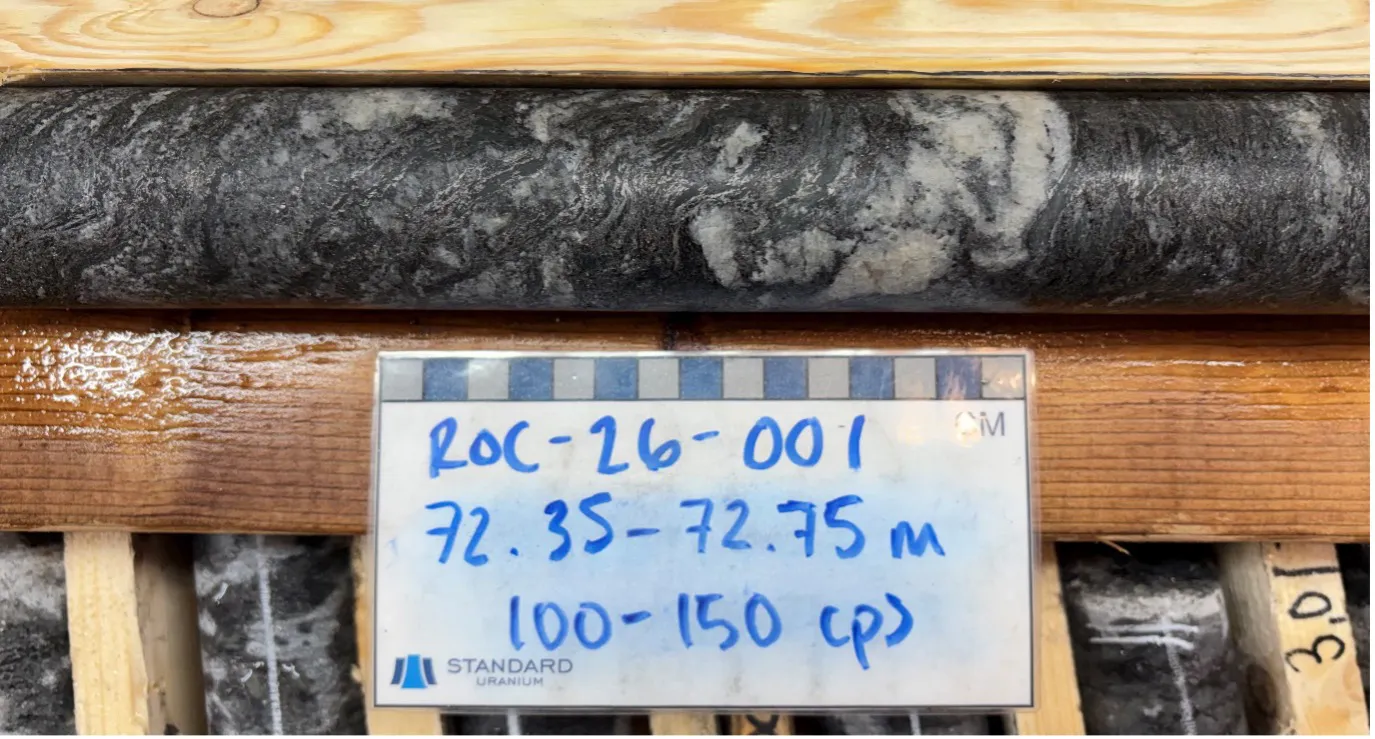
Core from hole ROC-26-001, 2026
Scroll the map sideways, or open it full size.
- Rocas dispositions
- Highway 914
- Uranium deposit (SMDI)
- Athabasca Basin sandstone (1:1M)
- Major shear zone (1:1M)
The target
The claims cover 7.5 km of a northeast-trending magnetic low that coincides with electromagnetic conductors and cross-cutting faults. In the eastern Athabasca, this combination of graphitic conductors and reactivated structure is the setting for basement-hosted uranium deposits.
Bedrock sits under thin glacial till, so the targets are shallow. The geophysical target zones are roughly 100 to 200 m below surface. Crews reach the property year-round on the highway.
Historical outcrop grab samples along about 900 m of strike graded up to 0.5 wt.% U3O8. No hole had tested them before 2026.2
The claims and what has been found on them
Rocas is three mineral dispositions totalling 4,002 ha, all held by Standard Uranium (Saskatchewan) Ltd. and in good standing. The provincial Mineral Deposit Index records 6 showings inside the claims. The provincial drillhole database records no holes inside them before Collective’s 2026 program.
Scroll the map sideways, or open it full size.
- Rocas dispositions (option to earn 75%)
- Other active dispositions
- Highway 914
- Lineament (1:250K)
- Uranium showing in the claims (SMDI)
- Thorium or REE showing in the claims (SMDI)
- Other historical showing (SMDI)
- Pelitic and psammopelitic gneiss
- Psammitic to meta-arkosic gneiss
- Amphibole gneiss, amphibolite
- Calc-silicate rock, marble
- Felsic gneiss
Dispositions
| Disposition | Area | Recorded | Good standing to |
|---|---|---|---|
| MC00017219 | 3,071 ha | May 10, 2023 | August 8, 2027 |
| MC00022909 | 539 ha | September 11, 2025 | December 10, 2027 |
| MC00022901 | 392 ha | September 11, 2025 | December 10, 2027 |
Recorded holder: Standard Uranium (Saskatchewan) Ltd. Collective’s interest is the option described below.
Showings inside the claims
| SMDI | Commodity | Record | Samples |
|---|---|---|---|
| 2465 | Uranium | Occurrence | Grab Samples 23901 and 23902 |
| 5778 | Uranium | Anomaly | Grab sample 85026 |
| 5781 | Uranium | Occurrence | Grab samples 85070 to 85073 |
| 5777 | Thorium | Anomaly | Grab sample 85025 |
| 5779 | Thorium | Anomaly | Grab sample 85063 |
| 5780 | Rare Earth Elements, Thorium, Zirconium | Occurrence | Grab sample 85064 & 85065 |
Sources: Saskatchewan Ministry of Energy and Resources. Mineral dispositions from the MARS register, bedrock geology and lineaments at 1:250,000, shear zones and the Athabasca Basin outline at 1:1,000,000, the Saskatchewan Mineral Deposit Index, and the Saskatchewan Road Network. Retrieved October 1, 2026. Contains information licensed under the Open Government Licence – Saskatchewan. Projection UTM zone 13N; grid ticks in kilometres.
Work on the property, oldest first
- 2007
Lakebed geochemistry
Lake-sediment samples above the 95th percentile for uranium, cobalt, vanadium and zinc along the conductor corridor, with high uranium-to-thorium ratios.
- 2017
Airborne electromagnetics
Airborne EM survey traced conductive trends west of and parallel to the Key Lake Road shear zone, with parallel conductors, offsets and terminations that point to cross-cutting structures.
- 2024–25
Ground gravity
High-resolution ground gravity survey by MWH Geo-Surveys, modelled by Convolutions Geoscience. Gravity lows, which can mark alteration, line up with surface mineralization, lake geochemistry and faults.
- 2025
- 2026
First drilling
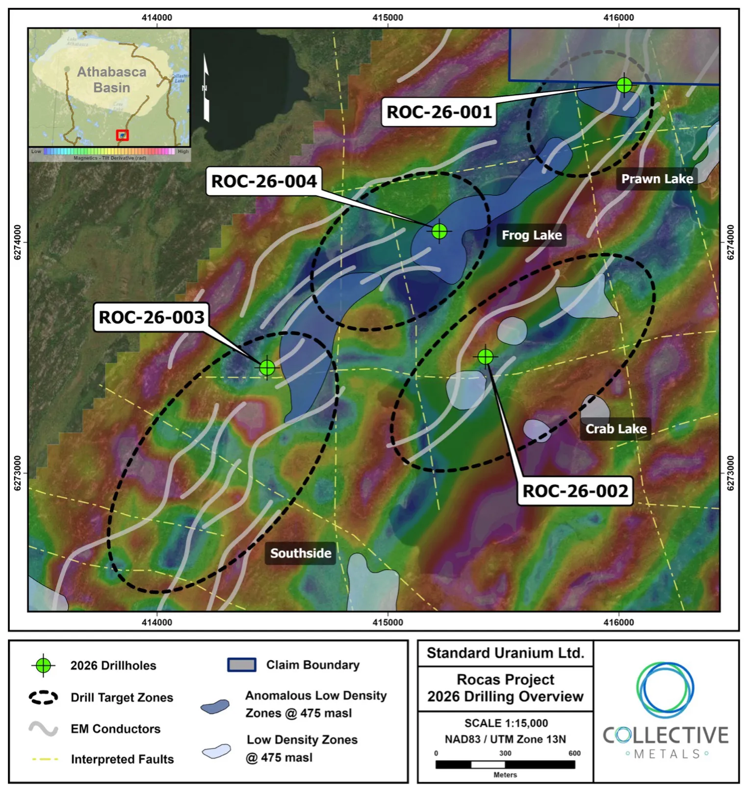
962 m in four holes at Upper Prawn Lake, Southside and Crab Lake. Graphitic metasediments in every hole and anomalous radioactivity in three, up to 650 cps over 0.5 m in ROC-26-001. Assays pending.
2026 drill program
Drilling started on March 16, 2026 and finished in early May. The plan was 1,200 to 1,500 m in six to eight holes. The program completed 962 m in four reconnaissance holes, ROC-26-001 to ROC-26-004.
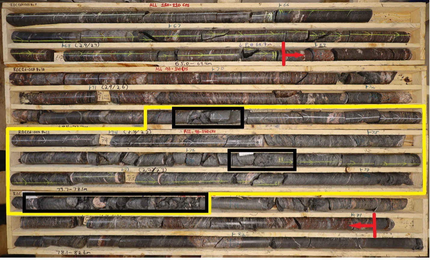
- Graphitic metasediments with sulphides in all four holes, confirming the electromagnetic targets.
- Brittle graphitic faults and clay gouge, which show the structure was reactivated and could carry fluids.
- Hematite and clay alteration, signs of hydrothermal activity.
- Anomalous radioactivity in three holes: 650 cps peak over 0.5 m in ROC-26-001 (208.5–209.0 m), 360 cps in ROC-26-003 and 320 cps in ROC-26-004. The holes total 1.5 m of composite anomalous radioactivity.3
Geochemical assays are pending. A second program is being designed to test more than 5 km of conductor that has not been drilled.


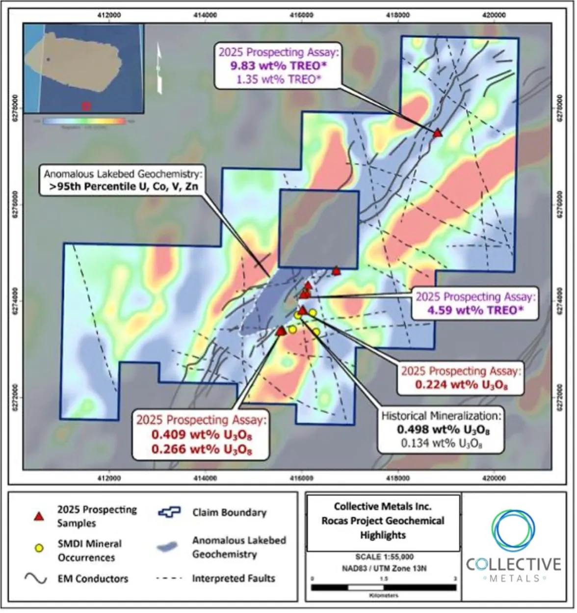
Rare earths at surface
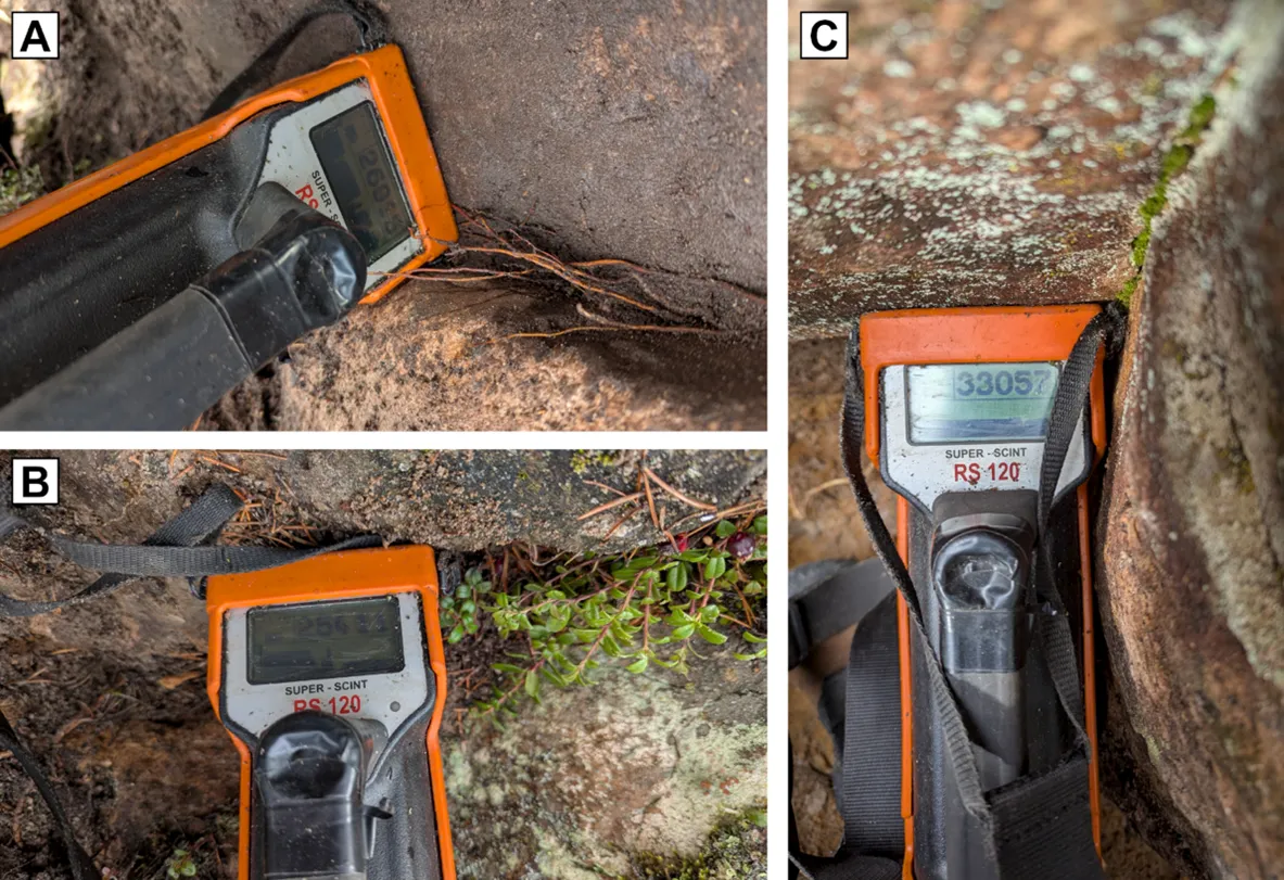
The 2025 samples showed that Rocas carries rare earth elements as well as uranium. A pegmatite outcrop found during the program assayed up to 9.83% TREO with 0.016% U3O8 in a grab sample.4
How Collective earns its interest
Collective signed a three-year option with Standard Uranium on September 26, 2025. To earn a 75% interest, it must make the payments, issue the shares and fund the exploration below. It earns nothing until all three years are complete. While the option runs, Collective is the operator and charges the fee shown. Standard Uranium’s team runs the fieldwork.
| Cash | Shares (value) | Exploration spending | Operator fee | Interest at year end | |
|---|---|---|---|---|---|
| Year 1 | C$75,000 | C$100,000 | C$1,500,000 | 10% | 0% |
| Year 2 | C$50,000 | C$275,000 | C$1,500,000 | 12% | 0% |
| Year 3 | C$125,000 | C$325,000 | C$1,500,000 | 12% | 75% |
| Total | C$250,000 | C$700,000 | C$4,500,000 | 75% |
The Year 1 cash payment was due five business days after Collective closed a non-flow-through financing of at least C$500,000.
Notes on the data
- Collective holds an option, not an ownership interest. It earns 75% only by completing all three years of payments, share issuances and exploration spending; until then its interest is 0%.
- Historical data from previous operators has not been verified by the Company or a qualified person; investors should not place undue reliance on it.
- Natural gamma radiation was measured in cps using a handheld RS-125 super-spectrometer and RS-120 super-scintillometer. Scintillometer readings are not uniformly or directly related to uranium grades of the rock sample measured and should be treated only as a preliminary indication of the presence of radioactive minerals.
- Grab samples are selective by nature and may not represent the mineralization on the property. TREO is total rare earth oxides.